


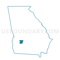
1771 - #1 Voting District, Lee County, Georgia
About
Outline

Summary
| Unique Area Identifier | 562360 |
| Name | 1771 - #1 Voting District |
| County | Lee County |
| State | Georgia |
| Area (square miles) | 102.08 |
| Land Area (square miles) | 98.70 |
| Water Area (square miles) | 3.38 |
| % of Land Area | 96.69 |
| % of Water Area | 3.31 |
| Latitude of the Internal Point | 31.83309760 |
| Longtitude of the Internal Point | -84.04348400 |
Maps


Graphs
Select a template below for downloading or customizing gragh for 1771 - #1 Voting District, Lee County, Georgia


Neighbors
Neighoring Voting District (by Name) Neighboring Voting District on the Map
- 081CONEY - CONEY Voting District, Crisp County, GA
- 081JAMES - JAMESTOWN Voting District, Crisp County, GA
- 17710 - #10 Voting District, Lee County, GA
- 1772 - #2 Voting District, Lee County, GA
- 1774 - #4 Voting District, Lee County, GA
- 26115 - LESLIE Voting District, Sumter County, GA
- 3218 - OAKFIELD Voting District, Worth County, GA
- 3219 - WARWICK Voting District, Worth County, GA
Top 10 Neighboring County Subdivision (by Population) Neighboring County Subdivision on the Map
- Cordele CCD, Crisp County, GA (21,800)
- Leesburg CCD, Lee County, GA (20,018)
- Philema CCD, Lee County, GA (6,693)
- Warwick CCD, Worth County, GA (2,779)
- Leslie-De Soto CCD, Sumter County, GA (2,725)
- Smithville CCD, Lee County, GA (1,587)
Top 10 Neighboring Unified School District (by Population) Neighboring Unified School District on the Map
- Sumter County School District, GA (32,819)
- Lee County School District, GA (28,298)
- Crisp County School District, GA (23,439)
- Worth County School District, GA (21,679)
Top 10 Neighboring State Legislative District Lower Chamber (by Population) Neighboring State Legislative District Lower Chamber on the Map
- State House District 147, GA (54,428)
- State House District 134, GA (47,935)
- State House District 152, GA (47,091)
- State House District 148, GA (41,718)
Top 10 Neighboring State Legislative District Upper Chamber (by Population) Neighboring State Legislative District Upper Chamber on the Map
Top 10 Neighboring 111th Congressional District (by Population) Neighboring 111th Congressional District on the Map
Top 10 Neighboring Census Tract (by Population) Neighboring Census Tract on the Map
- Census Tract 203, Lee County, GA (6,712)
- Census Tract 201, Lee County, GA (6,693)
- Census Tract 102.01, Crisp County, GA (5,483)
- Census Tract 9501, Worth County, GA (2,779)
- Census Tract 9508, Sumter County, GA (2,725)
- Census Tract 202, Lee County, GA (1,587)
Top 10 Neighboring 5-Digit ZIP Code Tabulation Area (by Population) Neighboring 5-Digit ZIP Code Tabulation Area on the Map
- 31763, GA (23,304)
- 31015, GA (21,938)
- 31787, GA (1,488)
- 31764, GA (1,296)
- 31796, GA (1,112)
- 31735, GA (817)
- 31743, GA (630)
- 31772, GA (482)